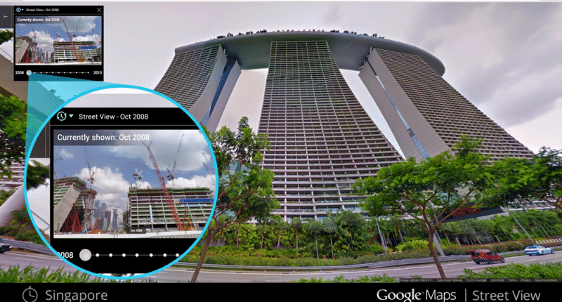
With over 220 billion Street View images from over 100 countries and territories, Street View has certainly been one of the most popular features that Google Maps has given us. It turned 15 today, and what better way is there to celebrate that, than by adding several enticing features that will improve the experience all the more? Ethan Russell, Director of Product, Google Maps, announced the same in a blog post.
The newest additions to Google Maps’ Street View include the ability to travel back in time to view the historical imagery of the place, new places to explore, as well as a new and improved camera. Here are they in more detail:
1. Traveling back in time
Wanted to see what a place looked like say, 7 years ago? Google will now make that possible. One of the newest additions to Street View will let you view all the historical imagery gathered and published by Google ever since Street View came into being in 2007. Think of it as a slide show that will show you the progress of a place over the past 15 years.
Your smartphone will act as a miniature time machine as Maps will let you view historical imagery of the place via Street View, once you access Google Maps on Android and iOS. All you have to do is click on the picture to see information about the location, click on “See more dates,” and then sit back to view the historical imagery.
2. A new camera
For the best experience and view locations perfectly, a proper camera needs to be employed to get high-quality pictures. Google Maps has kept the same in mind as it will bring its newest camera that will do exactly that, and what’s better is that it combines the power, resolution, and processing capabilities of an entire Street View car into a small and light camera that can be shipped without any inconvenience and captures 360-degree imagery.
Rolling out next year in “fun Google colors”, the camera will make it easier to capture Street View imagery even in traditionally un-mapped areas (Google gives the example of the Amazon rainforest). You can attach it to any vehicle with a roof rack and operate the camera with your mobile itself. Google says that this will allow them to explore more sustainable solutions for our current fleet of cars.
To cap this off, the camera is a customizable one, which means you can add components like lidar (laser scanners) to it if you want to collect more detailed imagery. These additions can be removed or replaced with others at any time, and continue to improve features such as Live View AR navigation.
These additions to Street View will make a more immersive map that is far more detailed, as well as help Google improve its Google Maps data.
3. More collections
Google Maps is also adding new collections of places such as the Pyramids of Meroë in Sudan, The Duomo in Milan, Les Invalides in Paris and the Sydney Ferries in Australia, to Street View. Users can view new panoramic imagery of the pyramids or the inside and exterior of the Duomo. For a change, they can take part in the virtual tour of Les Invalides in Paris or the same of Sydney Ferries in Australia in Australia as well.
If this is not enough, users will have eight more Street View images to view as well.
The Tech Portal is published by Blue Box Media Private Limited. Our investors have no influence over our reporting. Read our full Ownership and Funding Disclosure →


