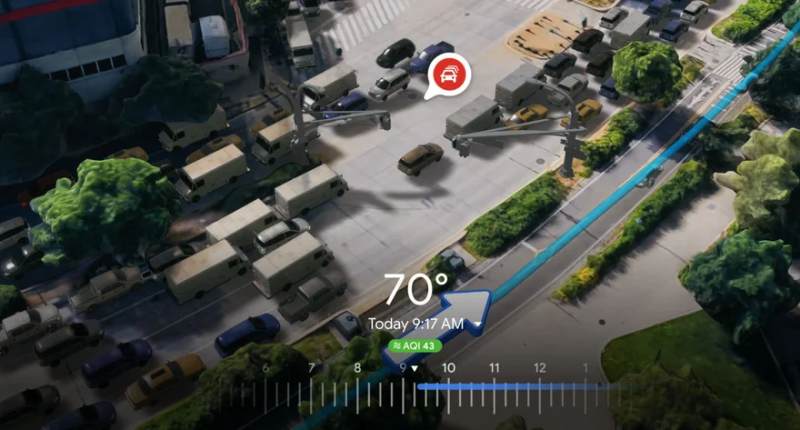
Google’s I/O 2023 turned out to be the venue for a considerable host of announcements. A top one among them is the new “Immersive View for Routes,” a feature that builds on the current Immersive View on Google Maps and is set to roll out in the coming months in 15 cities. And much like several of the other announcements, the feature heavily leverages AI to create a 3D view of a place.
The cities in question are Amsterdam, Berlin, Dublin, Florence, Las Vegas, London, Los Angeles, Miami, New York, Paris, San Francisco, Seattle Tokyo, and Venice. According to Google, Immersive View for Routes will come to Android and iOS alike and will help users get a better and far-more detailed understanding of a city before they actually visit it. They do so by bringing together details about traffic simulations, bike lanes, complex intersections, parking, weather conditions, and more, and users can use Immersive View for Routes while they are driving, walking, or cycling.
“Immersive View uses computer vision and AI to fuse billions of Street View and aerial images together to create a rich, digital model of the world. With this technology, you can see all the information you need about your route at once. When you get directions, you’ll see a multidimensional experience that lets you preview bike lanes, sidewalks, intersections, and parking along your journey,” Goole wrote in a blog post on the feature.
“With the time slider, you’ll see air quality information and how the route looks as the weather changes throughout the day, so you can be prepared with a jacket or sunscreen. And no matter what mode you take, AI and historical driving trends simulate how many cars might be on the road at a given time — because a route during a quiet afternoon can look very different during rush hour,” it added.
Some potential benefits of Immersive View for routes include a better understanding of travel directions, more efficient navigation, and an improved overall user experience. Additionally, businesses could leverage this feature to showcase their physical locations, attract new customers, and differentiate themselves from competitors. Instead of trying to follow a series of written directions or a 2D map, users will be able to see their entire route in 3D, which should help them better understand where they’re going and what they need to do to get there.
Another benefit of Immersive View for routes is that it will make travel more engaging and enjoyable. By providing users with a more immersive experience, Google hopes to encourage people to explore new places and discover new things along the way. The introduction of Immersive View seems to be part of Google’s continued efforts to enhance its mapping service and provide users with more immersive and engaging experiences.
To add to this, Google is also launching a new “Aerial View API” for developers to allow third-party uses of Google Maps’ Immersive View. It is currently available in preview and is set to allow developers to integrate 3D birds-eye videos of points of interest into their apps, which in turn offers people more visual information about a place. The new Photorealistic 3D Tiles via its Map Tiles API will help developers customize their 3D maps as well. Google cited the example of a tourism company, wherein it can create a 3D map of a national park with photorealistic imagery of mountains, water, and trees to attract travelers.
The Tech Portal is published by Blue Box Media Private Limited. Our investors have no influence over our reporting. Read our full Ownership and Funding Disclosure →


